
Tennessee Map
|
 |
 |
Where Is Tennessee?
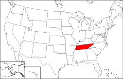
On this adjacent map, the location of Tennessee is highlighted in red. The State of Tennessee is bordered by Kentucky on the north, by Alabama on the south, by North Carolina on the east, and by Arkansas on the west. Tennessee is bounded by Virginia on the northeast, by Georgia on the southeast, by Missouri on the northwest, and by Mississippi on the southwest.
Tennessee Maps
Tennessee is the 34th largest state in the United States, covering a land area of 41,217 square miles (106,752 square kilometers). The state comprises 95 counties. This Tennessee map site features road maps, topographical maps, and relief maps of Tennessee. The detailed, scrollable road map displays Tennessee counties, cities, and towns as well as Interstate, U.S., and Tennessee state highways. The pannable, scalable Tennessee street map can be zoomed in to show local streets and detailed imagery.
Tennessee Highway Map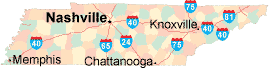 Click on the highway map thumbnail
to view a scalable Tennessee road map. |
TN Topo MapClick map to enlarge.
|
TN Relief MapClick map to enlarge.
|
The detailed Tennessee map and the regional Tennessee map display cities, roads, rivers, and lakes as well as terrain features. The detailed map shows only the State of Tennessee, while the regional map shows Tennessee and the surrounding region.
Tennessee Infrastructure > Tennessee Airports
In 2005, the population of Tennessee was estimated at 5,955,745, which is about 144.7 people per square mile. In 2010, Tennessee's population rose to 6,346,105 people. More recently, in the 2020 census, the Tennessee population was 6,910,840. The state's Interstate Highways include I-24, I-40, I-65, I-75, and I-81.
Tennessee Topography
Tennessee is derived from the name of a Cherokee village. The Great Smoky Mountains, dominate eastern Tennessee, and their foothills gradually descend to the Cumberland Plateau and fertile floodplains in western Tennessee. Years ago, the TVA harnessed the Tennessee River for hydroelectric power, and its dammed lakes are popular recreational areas. The Mississippi River runs south along the state's western edge. Great Smoky Mountain National Park as well as Chickamauga, Shiloh, and Chattanooga National Military Parks are important landmarks.
For Tennessee travel and tourism information, visit the official Tennessee tourism site and Tennessee Atlas.
Other Maps of Tennessee
This Tennessee reference map shows major cities, roads, railroads, and physical features in Tennessee.Several map publishing companies offer printed maps of Tennessee. For example, Omni Resources offers several maps of Tennessee that feature points of interest, airports, and parks, as well as selected local attractions and insets of major Tennessee cities.
All rights reserved.
Certain maps hereon are © Map Resources or Digital Wisdom.
To facilitate browsing, certain external links will open in new windows.
Tennessee-Map.org Editor, State Maps, PO Box 828, Barnegat, NJ 08005.